The biannual National Urban Design Awards program was established in 2006, through a partnership between the Royal Architectural Institute of Canada, the Canadian Institute of Planners, and the Canadian Society of Landscape Architects. For the past 18 years, it has aimed to recognize the achievements of interdisciplinary and multidisciplinary projects involving architects, planners, landscape architects, and other disciplines in creating places that enhance the quality of life in Canadian communities.
Submissions to the award include the winning projects from city-led Urban Design Award programs across Canada, as well as submissions received at-large.
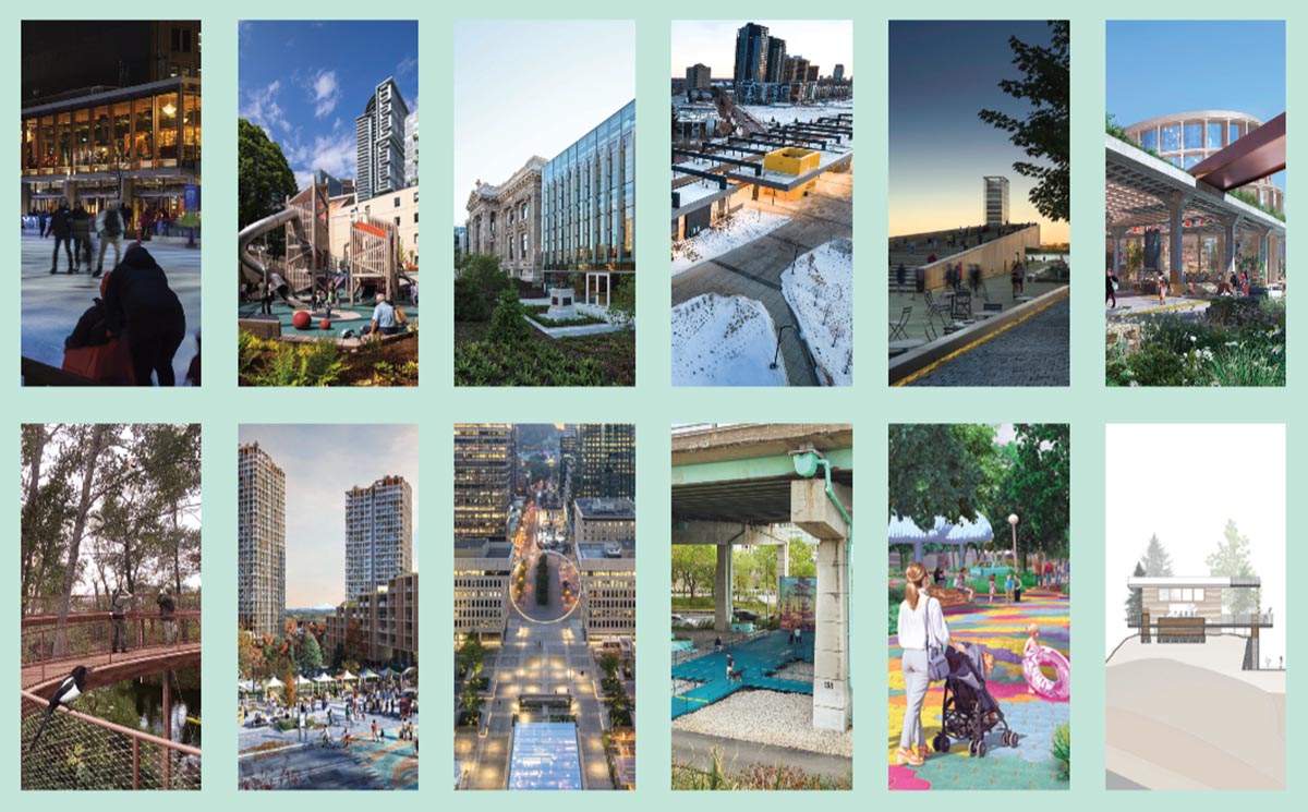
The 12 winning projects that follow showcase the highest achievements of Canadian architecture, landscape architecture, and planning in working together to create people-centered spaces for our country’s diverse urban communities.

ESPLANADE TRANQUILLE
Les architectes FABG et Fauteux et associés architectes paysagistes
LOCATION Montreal, Quebec
CATEGORY Civic Design
Montreal’s Quartier des Spectacles stands out among North American theatre districts with its innovative use of outdoor spaces for free, year-round artistic events. The last phase of Daoust Lestage’s ambitious masterplan to manage and develop the district’s network of public spaces is FABG and Fauteux et associés architectes paysagistes’ Esplanade Tranquille.
The project transforms a 5,000-square-metre vacant lot at the corner of St. Catherine and Clark Streets into an all-season public space. A linear service building borders the Esplanade, while the main plaza is occupied by an outdoor concert area in summer festival season and a refrigerated skating rink in the winter. On the north side, a section of the plaza accommodates a mobile stage. Moveable planters and furniture invite activity into the plaza, while allowing for easy conversion into an open-air performance venue. Completing the composition, trees planted at the perimeter limit the heat island effect.
The service pavilion is an assemblage of CLT wood boxes over a post-and-beam concrete plinth. Folding glass walls open the building’s ground floor to the plaza, and allow access to heated terraces on the first floor. The building also includes a green roof planted with an herb and vegetable garden used for the Esplanade’s restaurant. Geothermal wells under the rink’s surface provide energy to heat and cool the building, and waste heat is recaptured from the compressors of the rink’s refrigeration system.
Jury Comment :: Esplanade Tranquille is a very well executed all-season space that becomes a collective gathering space for the active public to congregate. The design team’s collaboration is apparent in the flow between interior and exterior spaces and the animated level of activity day and night. This once derelict space has been transformed and brought to life with its moveable planters and furniture and vibrant, year-round activities. The idea of a metropolis with a diverse and rich central public place combining exterior and interior spaces is a visionary innovation worth recognizing.
CLIENT City of Montreal | ARCHITECT TEAM Éric Gauthier (FRAIC), Marc-Antoine Fredette, Amandine Mortka, Vincent Désy, Steve Montpetit, Catherine Doyon-Couturier, Pierre Joly, Giselle Bouron, Roberto Pareja, Anna Kreplak | CONTRACTOR TEQ Inc. | LANDSCAPE ARCHITECTURE Fauteux et associés | MECHANICAL/ELECTRICAL/CIVIL/STRUCTURAL WSP | REFRIGERATION Petropoulous, Bomis et Associés | URBAN FURNITURE Alto Design and Dikini | INTERIORS Zébulon Perron | THEATRE Sceno plus | AREA 4,959 m2 (Interior); 5,400 m2 (exterior) | BUDGET $51.7 M | COMPLETION January 2022
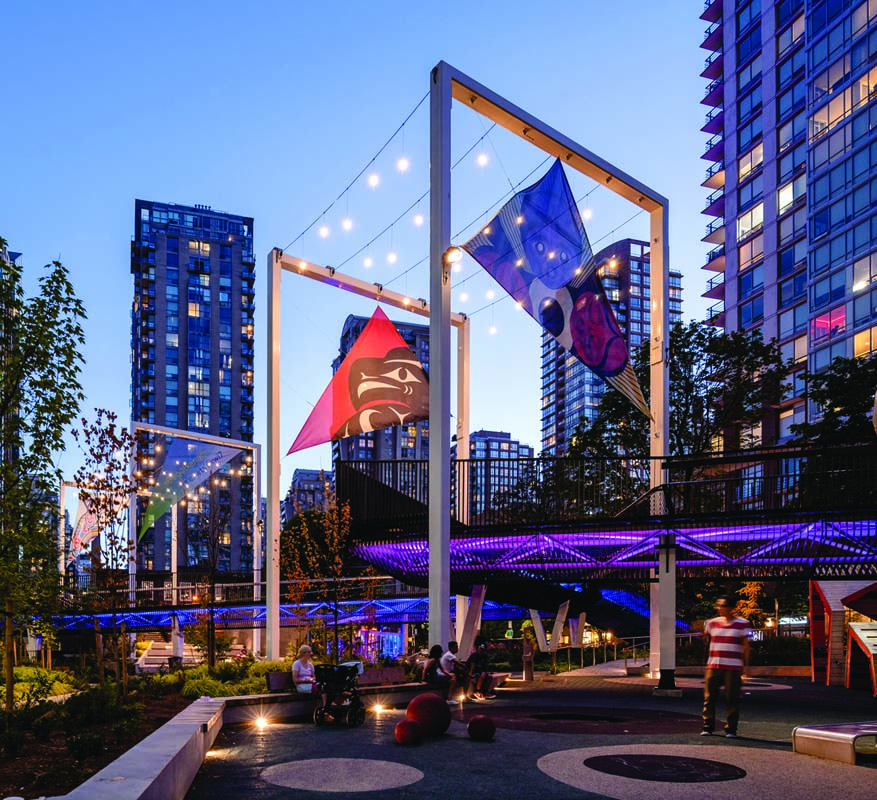
SΘQLXENM TS’EXWTS’ÁXWI7 (RAINBOW PARK)
DIALOG
LOCATION Vancouver, British Columbia
CATEGORY Civic Design
The name of this new park, sqlxenm ts’exwts’áxwi7, was gifted by Musqueam, Squamish, and Tsleil-Waututh Nations, and recognizes the site as a soft place known for abundant water where sun and mist danced around marshlands forming rainbows. Historically, it became a popular destination for the LGBTQIA+ community before being levelled for parking.
The vision to revive the site as the Vancouver Park Board’s first new park in a decade was grounded in collaboration with the surrounding downtown communities. The result is an innovative, high-capacity, three-dimensional community space within a dense downtown that encourages relationships between shared histories and land. This was achieved through the creation of multilevel, multigenerational space; playful grading and experiential low impact design; and careful selection of culturally relevant plants.
Three terraces negotiate the site’s 4.5-metre drop from north to south. As the land descends, a finely detailed bridge rises and zigzags above the urban world below. The lower terrace folds upwards into an urban amphitheatre and café around the multi-use plaza and houses the mechanical room.
The dynamic design also includes Host Nation artwork, a bouldering zone, a twisting slide, built-in trampolines, urban hammocks, a multi-use splash pad, and rainwater-collecting pocket wetlands. Sweeps of meadow, woodland, and marshland are climate resilient and directly respond to the microclimates created by grade changes and the overhead walkway. An urban ecology arises that imprints traditional plants into the collective memory, promising a deeper connection to a shared and hopeful ecological future.
Jury Comment :: Rainbow Park is an exceptional example of a public engagement strategy with its tightly knit spaces intertwining neatly within the multi-level design. It’s a new way of imagining a public square within a context of high real estate densification.
The metaphor of water and light through a rainbow expresses an idea that connects the Musqueam, Squamish and Tsleil-Waututh Nations together, while also speaking to the public using the space. A strong collaboration across the design team is evident, and the integration of native plant materials was completed thoughtfully. The garden shows how design can express the importance of change and reconciliation.
The park seamlessly recognizes and integrates the history and presence of Indigenous life in Vancouver. The walkway offers a unique view of the city and neighbourhood, while the experience of walking through it is similar to the New York City High Line on a smaller scale.
CLIENT Vancouver Board of Parks and Recreation ARCHITECT AND LANDSCAPE ARCHITECT TEAM Joost Bakker (FRAIC), Jill Robertson (FCLSA), James Godwin, Brady Dunlop (MRAIC), Dan Guenter, Paul Giles, Ryan McClanaghan, Stephanie Fargas Amador, Matthew Thomson, Mandy Yu, Steven Oosterhof, Thomas Wu, Cameron Franchuk, Graeme Johnston, Dan Prescott, Keith McDonnell, Andre O’Neill, Elizabeth Hand, George Unger, Elizabeth Orallo, Katherine Hurst | CIVIL WSP Canada ELECTRICAL AES Engineering | MECHANICAL/STRUCTURAL DIALOG ENVELOPE Elemental | CODE LMDG PLAY EarthScape | INTERIOR (CAFÉ) Scott Cohen | AREA 3,237 m2 (site) | BUDGET $13.8 M | COMPLETION April 2022
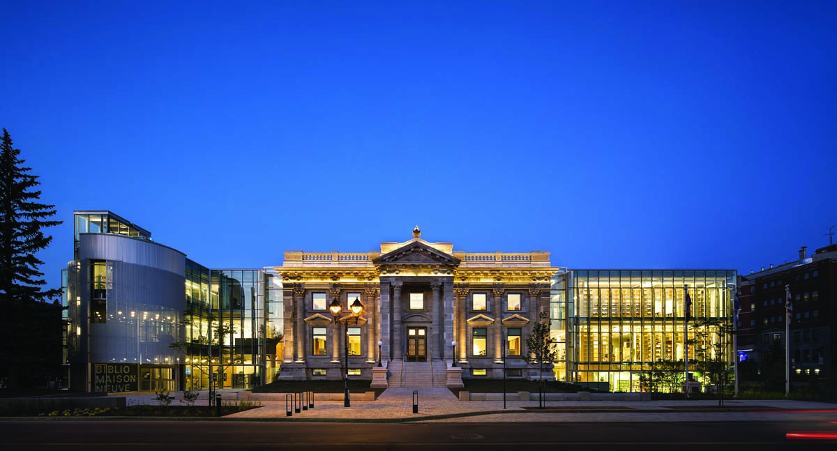
MAISONNEUVE LIBRARY RESTORATION AND EXTENSION
EVOQ Architecture + civiliti
LOCATION Montreal, Quebec
CATEGORY Urban Architecture
The new Maisonneuve Library forms an urban and architectural ensemble centered around the Cité de Maisonneuve’s former City Hall, built in 1912 by architect Joseph-Cajetan Dufort. The municipal building was occupied by various institutions until it became part of the public library network in 1981, and in 2017, a multidisciplinary design competition was launched in order to upgrade and expand the facility. The winning team was a consortium of Montreal firms led by EVOQ Architecture and Dan Hanganu Architects (now part of EVOQ) with the collaboration of urban design and landscape firm civiliti.
One of the most important decisions taken by the architectural team was to rehabilitate the historic building and bring it back to its original splendour. The project also includes the addition of two contemporary wings carefully aligned with the heritage building, and the creation of a distinctive landscape that erases the boundary between the public realm and the institution’s private grounds. Thyme ‘carpets’, granite furniture, a sunken garden, and a subtle pattern of grey pavers create a dignified setting for the old City Hall, and harmonize with the library’s resolutely contemporary wings. The project extends to include the urban spaces adjacent to the library and the Maison de la culture Maisonneuve, as well as Place Ernest-Gendreau at the back of the library.
The project’s architectural, urban, and landscape design mark this cultural hub as an important and accessible public space on Ontario Street.
Jury Comment :: The restoration and enhancement of Maisonneuve Library is a beautiful execution of the merging of old and new, heritage and modern, civic and public space and a thoughtful landscape solution to complement the building. The project reflects a sensitive understanding of the urban and social history of the area, while the consideration of materials and grand scale of the project solidify it as a true landmark within the city.
From the architectural expressions to the landscape details tying the site together, this is a very inviting place and a great celebration of civic investment in a community.
CLIENT City of Montreal, Mercier-Hochelaga-Maisonneuve Borough DESIGN TEAM MEMBERS Gilles Prud’homme, Peter Soland, Sylvie Peguiron, Marianne Leroux, Nathan Godlovitch, Anne-Catherine Richard, Lynda Labrecque, Alexis Charbonneau, Georges Drolet, Fannie Duguay-Lefebvre, David Murray, Etienne Ostiguy, Martine Vincent, Jean-François Bédard | BUILDING ENVELOPE ULYS Collectif | STRUCTURE NCK | CIVIL Génipur | MECHANICAL/ELECTRICAL Pageau Morel BUILDING | ENVELOPE/QUALITY CONTROL UL CLEB | ELEVATOR EXIM DOOR HARDWARE/BUILDING COMMISSIONING Cima+ | FURNITURE, WAYFINDING, MULTIMEDIA GSM Project | ERGONOMICS Vincent Ergonomie | LIGHTING LightFactor | SUSTAINABILITY WSP | ACOUSTICS Octav | HISTORIC DOORS, METAL M&B Métalliers | MOSAIC Artès Métiers d’art ORNAMENTAL PLASTERS Plâtres Artefact | MASONRY Maçonnerie Rainville et Frères RESTORER, MASONRY Trevor Gillingwater | STONE CUTTERS Alexandre, Tailleurs de pierres + sculpteurs | STAINED-GLASS WINDOWS Studio du verre ARTIST | PUBLIC ART WORK Clément de Gaulejac | BUDGET $33.6 M | AREA 4,138 m2 | COMPLETION December 2023
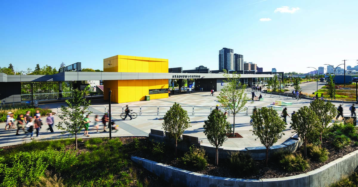
STADIUM STATION
GEC Architecture
LOCATION Edmonton, Alberta
CATEGORY Urban Architecture
One of Edmonton’s original five LRT stations, the 1970s Stadium Station no longer met the community’s evolving needs or the city’s long-term
development goals. Extensive physical barriers, inward-facing and enclosed public areas, and grade-separated station access contributed to challenges in providing a safe and accessible experience.
GEC Architecture (GEC)’s design transformed the transit infrastructure from a barrier between communities into something that stitches them together, instigating urban rejuvenation and vibrant redevelopment.
The new station and its supporting infrastructure integrate into the public realm, serving as an armature to realize the Stadium Station Area Redevelopment Plan’s goals of creating a sustainable transit-oriented community. Key to this integration was creating a contiguous urban realm that flows around and through the station, yielding seamless connectivity and visual permeability. A central plaza, which is universally and visually accessible at grade from every direction, has become a meeting place for the community.
Much of the original station remains intact as part of the new infrastructure, with the original underground concourse converted to back-of-house spaces and emergency egress routes. At the surface, the facility was converted from a grade-separated, centre-loaded platform to an at-grade, side-loaded station. Reconstruction of the station was achieved while maintaining continuous transit operations—a feat requiring exemplary interdisciplinary coordination.
Before GEC’s design intervention, Stadium Station was one of the top three facilities in the city for police and enforcement calls; it is now among the top three safest facilities in the Edmonton system.
Jury Comment :: Stadium Station is a very bright and inviting celebration of transit investment needed to reconnect a community to transit and upgrade the rider experience. It is a sensitive and thoughtful response to existing urban issues and is commended for its design emphasis on an infrastructure building.
As a new piece of the public realm and an integral part of the community, this project acknowledges the value of design. The contemporary forms, strong landscape moves, public plazas, and bold public gestures together make this project feel like a bright and inviting public space. The playfulness of the colour and the strong linear lines help unite this piece of the city and lift the overall experience.
CLIENT City of Edmonton ARCHITECT TEAM MEMBERS Gary Mundy, Tyson Bolduc, Rob Wenarchuk, Charles Fung, Tim Morasch, Shayne Yap, Kyla Hall, Ethan Cohen | STRUCTURAL Read Jones Christoffersen Ltd. | MECHANICAL/ELECTRICAL/CIVIL (PHASE 2+3) Stantec | COMMUNICATIONS/LRT SIGNALS/LRT TRACK Stantec | SIGNALS COMMISSIONING Hatch | LANDSCAPE ISL Engineering | TRACTION POWER Platinum Engineering | CROSSING SAFETY WSP | BUDGET $45 M | AREA 7,000 m2 (including platforms, plazas, transit centre, pedestrian connections and landscaping) | COMPLETION December 2022
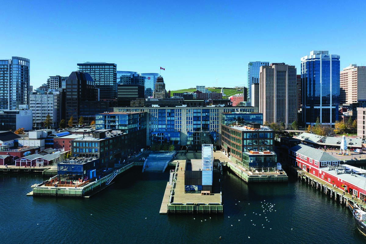
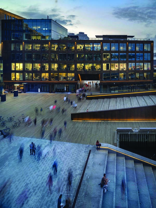
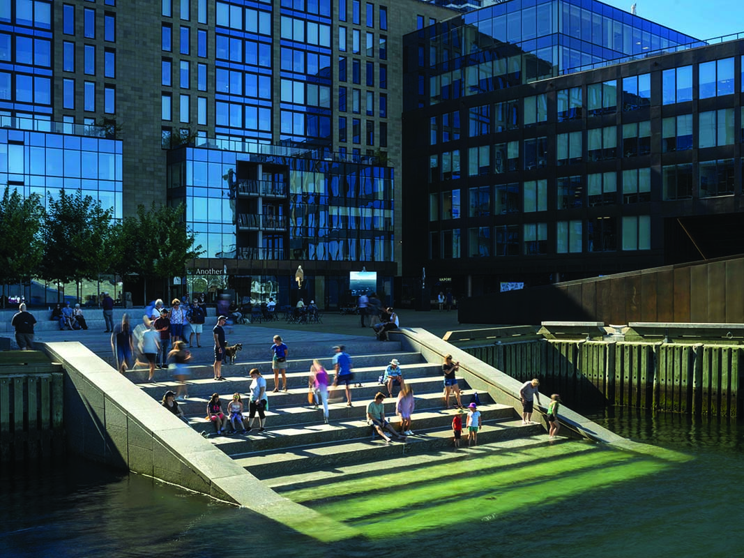
QUEEN’S MARQUE
MacKay-Lyons Sweetapple Architects (Design Architect and Urban Design) with FBM Architects (Prime Consultant)
LOCATION Halifax, Nova Scotia
CATEGORY Urban Architecture
Queen’s Marque was born from the developer’s desire to build a significant Canadian landmark that would be created by Nova Scotians, for Nova Scotians. Through deliberate planning and sensitive design, Queen’s Marque is conceived as a district, with the aim to contribute to Halifax’s downtown urban fabric.
The design devotes 70 percent of the site to open public space, and includes the city’s first significant public gathering place along the harbour. Multiple passages through the buildings make the development highly porous to the public, including lending direct access into the water via a riverside staircase.
The design began by moving parking underground and developing a mixed-use program to keep the site active 24/7. The configuration of the complex preserves views to the historic citadel, extends the civic grid to the water, repairs and completes the pedestrian boardwalk along the shoreline, and establishes a protected microclimate. Materials speak to the local vernacular, and the development includes many site-specific art installations that reference the harbour’s history and the local environment.
Queen’s Marque has been designed to meet LEED Platinum standards. The development saves on cooling costs by using the frigid water of the harbour in a seawater loop. In anticipation of sea level rise, the ground level of the project has been raised, but remains engaged with the surrounding pedestrian experience.
Jury Comment :: Queen’s Marque is a well-executed project demonstrating the balance between subtle architectural forms and open space where the city meets the water. The placement of buildings, the access to the water at Queen’s Landing, and the ambitious energy modelling using the local seawater all contribute to the meaningful relationship to the waterfront. The thoughtful consideration of climate change and how water meets the land is notable, as is how the local place, culture and design are expressed in the specifics of the Halifax environment. The thoughtfulness put into bringing this site to life is commendable. The project reflects the collaboration of various experts and is anchored in its history and geography. The project reveals the genius of the place and reflects a sensitivity to history, place, communities, art, and poetry.
DEVELOPER AND MASTER BUILDER Armour Group Limited (Scott Armour McCrea) | ARCHITECT TEAM MacKay-Lyons Sweetapple Architects—Brian MacKay-Lyons, Shane Andrews, Will Perkins, Rimon Soliman, Izak Bridgman, Tyler Reynolds. FBM Architects—George Cotaras, Wayne Duncan | STRUCTURAL Campbell Comeau Engineering Ltd. | MECHANICAL/ELECTRICAL M + R Engineering | LANDSCAPE Fathom Studio and Brackish Design Studio; Queen’s Landing Staircase—MacKay-Lyons Sweetapple Architects (Concept Design) and Fathom Studio (Detailing) | BUILDER Armour Group Limited in joint venture with Bird Construction | URBAN DESIGN MacKay-Lyons Sweetapple Architects | INTERIORS Muir Hotel—Studio Munge; Lobbies, core and residences—MacKay-Lyons Sweetapple Architects | PUBLIC ART Tidal Beacon—Ned Kahn, Heavy Industries & MacKay-Lyons Sweetapple Architects; The Sirens’ calling—John Greer; Water—Thaddeus Holownia; The Light Chocks—MacKay-Lyons Sweetapple Architects with Heavy Industries; Sail—Tresoldi Studio | AREA 41,800 m2 | BUDGET Withheld | COMPLETION Spring 2023
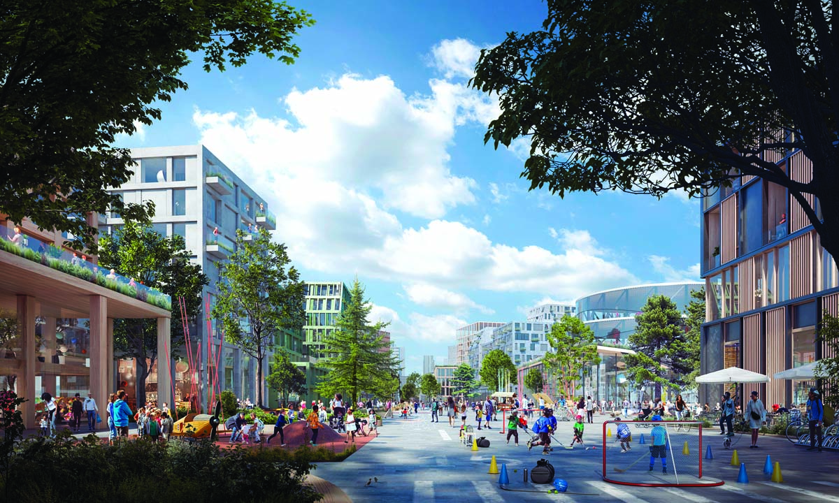
DOWNSVIEW FRAMEWORK PLAN
Henning Larsen (urban design); KPMB Architects (architecture); SLA (landscape); Urban Strategies Inc. (planning)
LOCATION Toronto, Ontario
CATEGORY Urban Design Plans
People, place, and nature come together in this vision that will transform 520 acres of brownfield in Toronto into complete, connected communities. Downsview will become home to over 80,000 residents and create over 40,000 jobs. The Framework Plan will involve the design of 100 acres of new parkland, 1.2 million square meters of commercial and light industrial real estate, and 50,000 new units of housing across the full spectrum of affordability.
With the closure of Downsview Airport, the site—bisected by a regional commuter rail corridor, and with three major transit stations at its perimeter—represents one of the most significant city-building opportunities in North America. The vision is centered on adapting the airport runway as a two-kilometre-long, pedestrian-focused open space lined by active uses and interspersed with large urban parks. New public realm elements create connections to the city’s ravine system and surrounding open spaces.
The Plan contributes to Toronto’s goal of a low-carbon future by delivering density at a comfortable, predominantly mid-rise scale. This approach to density takes advantage of existing transit investments and supports local opportunities to live, work and play. Walking and cycling are encouraged via the reimagined runway and a network of streets and spaces that prioritize active mobility. Climatic conditions and outdoor comfort guide decisions about block orientation, street alignments, and building massing. Deploying “blue-green infrastructure,” the 100 acres of new parks, along with streetscapes, courtyards, and buildings, will work together as an integrated nature-based stormwater management system.
Jury Comment :: Converting one of the largest contiguous spaces in Toronto into a nature-first community is ambitious. The 520-acre brownfield area comes with a strong history of an airport and requires a thoughtful re-integration of the city fabric across the lands. An ambitious goal that has been crafted by input from citizens, it is an example of how sustainable development can occur. Big ideas and aspirations are well bundled into this master plan with a strong focus on nature in the city. The plan focuses on six fundamental principles: nature, equity, accessibility, people, sustainable development, and transit proximity.
The framework plan demonstrates good analysis of the site and its context. The plan aims to incorporate sustainable principles, connect to its surroundings, integrate public transit into its design, and create walkable communities. This project is a demonstration of how a once-negative industrial site can be transformed into a valuable resource for future generations and should be used as an example for other municipalities.
CLIENT Northcrest Developments and Canada Lands Company | DESIGN TEAM Henning Larsen: Michael Sørensen, Santiago Orbea, Gregory Haley, Francis Aguillard, Evan Shieh, Grant McCracken. KPMB Architects: Kevin Bridgman, Laurence Holland, Sahana Dharmaraj, Shirley Blumberg, Bruce Kuwabara, Geoffrey Turnbull, Jonathan Graham, Nellie Jalal-Zadeh, Andy Barat. SLA: Rasmus Astrup, Salka Kudsk, Nicoline Heather Madsen, Alessia Cacopardo, Francisca Álvarez, Anne Sofie Sørensen, Kristine Kjørup Rasmussen. Urban Strategies Inc.: Emily Reisman, Frank Lewinberg, Michel Trocme, Christine Fang-Dennisov, Giuseppe Tolfo | MUNICIPAL INFRASTRUCTURE ARUP | SUSTAINABILITY/CLIMATE RESILIENCE Ramboll | SUSTAINABILITY Purpose Building | PUBLIC ENGAGEMENT Third Party Public, Department of Words and Deeds | INDIGENOUS ENGAGEMENT Nibisiing Consulting Inc. EQUITY ADVISORS Monumental Projects Inc. | COMMUNICATIONS DESIGN Future Simple Studio | TRANSPORTATION BA Group ENERGY Transsolar | AREA 520 acres | COMPLETION September 2021
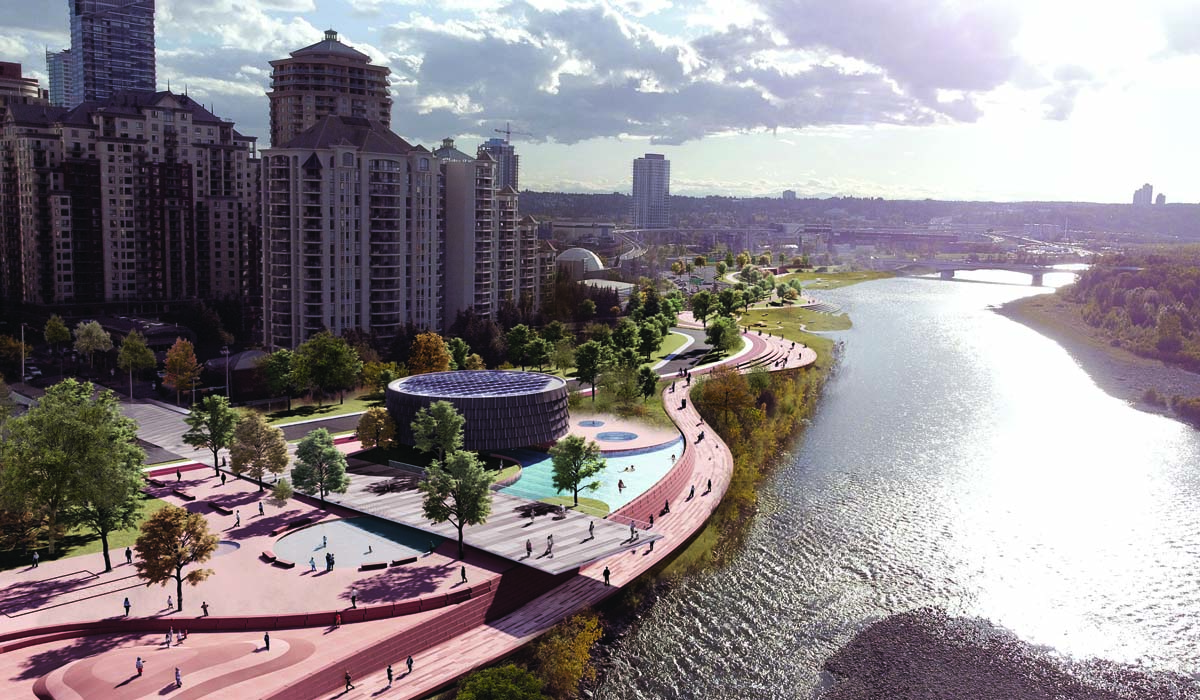
EXCHANGE: REALIZING RIVERWALK WEST
groundcubed (Ground3 Inc.), HEREBY Architectural Inc., SIKOMH KOKOMII, Bunt & Associates Engineering Ltd., Martinson Golly Ltd., RJC Engineering
LOCATION Calgary, Alberta
CATEGORY Urban Design Plans
The winner of the City of Calgary’s first public realm design competition, this proposal for the redevelopment of the south bank of the Bow River leverages a need for pathway connectivity to create a vibrant, inclusive public realm that responds to—and amplifies—its unique Bow River ecosystem context, while serving as a catalyst for broader civic transformation.
The plan’s “big moves” include strategically reconfiguring adjacent streets and consolidating underused parcels to re-acquire the river’s edge, softening the riverbank, balancing natural and urban eco-systems, and creating a dynamic pathway that undulates with the new topography. The design enhances wetland and fish habitats through ecosystem regeneration, and provides opportunities for Calgarians, and the city’s visitors, to view, access, and touch the Bow River. It does this all while satisfying the growing need for multi-modal connections to and through the city’s Downtown West.
The design approach and final proposal is shaped by traditional ways of knowing the land, shared by local Blackfoot Elders. From their stories, ideas of discovery, ceremony, gathering together from all over, art, exchange, and teaching emerged as significant to this place.
These ideas are central to the definition of six character areas, each with a unique approach to promoting thriving cultural and natural ecosystems: West Village Riparian Trail, Grassland Bowl, Main Street, Land Art Island, The Exchange, and Trickle Creek + Constructed Wetland.
“groundcubed’s design is very compelling, founded in the cultural and historical influences on the site and telling a story that recognizes everyone’s voice, both past and present,” wrote the City of Calgary’s design competition jury. “The concept is smart and thoughtful and meets all the key goals of the project.”
Jury Comment :: Building upon the Indigenous practice of meeting at the water’s edge, this master plan embraces the interplay between land and water, and keeping this as a car-free, active experience. The flow of circulation, creating spaces and diversity of experiences is well portrayed through plans and renderings.
RiverWalk West showcases rich cultural diversity and a coherence with existing public spaces, and demonstrates how multi-use pathways can connect a city. Respectful and ambitious, the project shows excellent sensitivity to context and community history. The richness of the spaces and the opportunities for exchange of ideas, stories and culture by the people who share the river is well expressed, and is an aspirational goal.
CLIENT City of Calgary DESIGN TEAM MEMBERS groundcubed: Greg Stewart, Emma Brodie, Michael Chamberlain, Jaimie Johnson, Benjamin Hettinga, Jonathan Sagi, Trent Workman, Andrea Kennedy, Justin Bhatia, Tessa Larsen. HEREBY: Matt Stewart, Yves Poitras, Michael Zabinski. SIKOMH KOKOMII: Jared Tailfeathers. Bunt & Associates: Glen Pardoe. Martinson Golly: Ryan Martinson. RJC Engineering: Kieran Gaston. BUDGET $40-55 M AREA 74,000 m2 COMPLETION OF PLAN September 2023
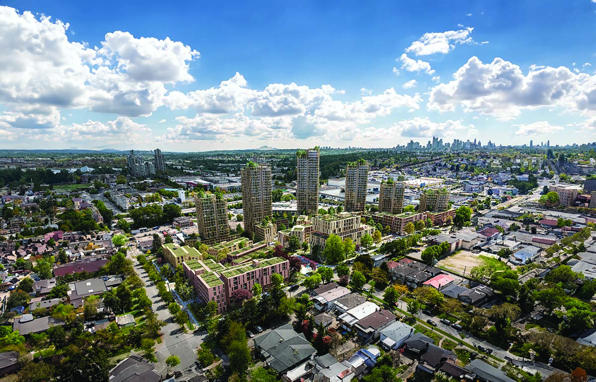

SKENNA TERRACE COMMUNITY PLAN
Perkins&Will with PWL Partnership Landscape Architects
LOCATION Vancouver, British Columbia
CATEGORY Urban Design Plans
Skeena Terrace is home to a diverse community on 4.4 hectares in Vancouver, and includes a terracing landscape designed by Cornelia Hahn Oberlander, but its 1960s-era buildings require extensive repairs. The community plan to revitalize Skeena Terrace protects and enhances the site’s urban forest, while planning for new buildings that significantly increase the supply and diversity of affordable rental housing on the site. The plan envisages an equitable community with 1,930 new units, 60% of which will be family-oriented, within a 10-minute walk of Rupert Skytrain Station.
Prioritizing tenant rights, the development minimizes off-site displacement and performs robust engagement to ensure needs are met and culture remains intact. The existing Thunderbird school and community centre are emphasized as the focal point to the neighbourhood, and enhanced through a new adjacent public plaza, childcare, and local-serving retail. At the heart of the plan, the “Skeena Hut”—an existing multi-purpose community facility—is recreated to anchor the redevelopment.
In the new development, communal outdoor courtyards are sited around the existing open spaces and significant tree groves. These “neighbourhood rooms” are connected through a greenway and path network that privileges active mobility and accessibility.
Buildings are contextually sensitive and sited to mitigate steep slopes and protect existing trees; below-grade, structures are set back from on-site water courses and significant trees. The design includes a centralized public space built around a celebrated watershed feature tracing the topography of the site. This landscape-driven approach results in building site coverage under 40%.
Jury Comment :: This intensive community plan, based on adding housing units, exemplifies a well thought-out relationship between buildings and open space. Skeena Terrace Community plan’s balance of community needs for facilities, open spaces, daycares, and urban agriculture exemplifies a people-centered approach to intensification. The plan is well-presented and executable, and can serve as a model for other communities with a similar history as they move forward and reinvent themselves.
The master plan aims to transform a community into a transit-oriented one, with seamless connections to surrounding areas. The plan creates a hierarchy of open spaces that are framed by buildings and link to the larger open spaces. The overall design is well anchored in the values and objectives of our time.
CLIENT BC Housing ARCHITECT TEAM MEMBERS Joseph Browner, Xiangdi Cai, Long Dinh, David Dove, Andrew Gavel, Rossana Ho, Islam Ibrahim, Jason LeBlanc, Negin Shakibi, Kathy Wardle, Akiko Watanabe LANDSCAPE PWL Partnership PLANNING & ENGAGEMENT Modus Planning Design & Engagement LAND ECONOMICS Liveable City Planning Ltd. ACCESSIBILITY Level Playing Field Inc. CIVIL Binnie TRANSPORTATION Bunt Engineering AREA 43,170 m2 COMPLETION OF PLAN December 2023 ESTIMATED COMPLETION OF PROJECT 2027 (Phase 1)
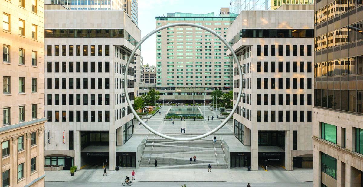
THE RING / L’ANNEAU
CCxA Architectes paysagistes Inc.
LOCATION Montreal, Quebec
CATEGORY Urban Fragments
The recent revitalization of Place Ville Marie included the construction of a stairway between the historical McGill College Avenue and the elevated Esplanade—an element integral to architects Henry Cobb and I.M. Pei’s original 1962 design intention. CCxA was mandated to suspend a signature sculpture above this new threshold to signify a new urban gateway.
The Ring is a formal counterpoint to Place Ville Marie’s orthogonal purity. Scaled on the proportional constraints of the existing buildings, the circular form frames a view that encompasses 200 years of history, leading through the financial district and the McGill University campus, up to the Royal Victoria Hospital and the illuminated cross on Mont Royal.
Although an unconventional work of landscape architecture, The Ring was realized through the unique strengths that are the hallmarks of the CCxA practice: blurring boundaries between design and art, placemaking through spatial arrangement, connecting an urban framework to prioritize the pedestrian experience, and coordinated across a diverse team of consultants and stakeholders. The landscape architects orchestrated and led an expert team made up of ten distinct disciplines who worked through continually emerging challenges. This spanned from metallurgy, vortex-induced oscillation, weld strengths, glass-bead sandblast finishes, and illumination on various metal finishes, to the complex choreography to precisely position and secure the 23-tonne, 30-metre-diameter object. The process also involved many cycles of risk assessment and myriad approvals, including from architect Henry Cobb’s office.
Embodying a deep love for Montreal, The Ring engages the public imagination and has already become an iconic part of Montreal’s cityscape.
Jury Comment :: The Ring is a simple, yet powerful, landmark in downtown Montreal. The project, situated in Place Ville Marie, is based on the historical development and urban structure of Montreal. The idea is clear, the expression is simple, and the execution is strong, demonstrating creative leadership and a significance in reconnecting the city to its past. This contemporary solution is applied with absolute clarity, serving as a key urban fragment that effectively unites time and space, while effectively framing various views of the city.
The Ring is an iconic work of urban art that strikes a balance between audacity, elegance, efficiency, and control while magnifying the experience of the city.
CLIENT Ivanhoé Cambridge | Landscape Architect Team CCxA (formerly Claude Cormier et Associés): Claude Cormier, Sophie Beaudoin, Damien Dupuis, Yannick Roberge | Fabrication and Installation Advisor Claude Bernard – Formaviva Inc. | Lighting Designer Gilles Arpin – Ombrages / EP Éclairage Public | Structural Franz Knoll – NCK | Industrial Design Advisor Michel Dallaire | Masonry and Sealing COHÉSIO Architecture | Mechanical/Electrical Stantec | Technology Integration The Attain Group | Machining/Fabrication/Assembly Marmen Inc. | Tube Bending Bendtec | Building Work JCB Construction Canada | Wind RWDI | Electricity Patrice Blain Entrepreneur Electricien | Blasting Sablage au Jet 2000 | Budget $5 M | Completion September 2022
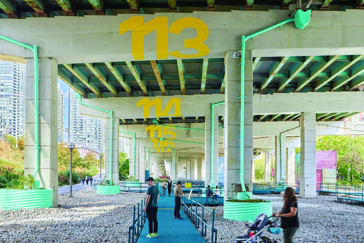
BENTWAY STAGING GROUNDS
SHEEEP in partnership with Agency—Agency
LOCATION Toronto, Ontario
CATEGORY Urban Fragments
Transforming a vacant space below the Gardiner Expressway into a living laboratory, Bentway Staging Grounds collects and leverages runoff water from the highway above to irrigate large planters in the space below. These planters support the growth of diverse, flowering native plant species such as Milkweed, Agastache and Yarrow, while passive water filtration and retention helps to reduce the risk of local flooding.
In order to track how the system is doing, monitoring technology in the experimental planters tests for water quality, flow volume, and soil health. This information informs ongoing maintenance requirements to keep the planters operational and provides valuable insight into how stormwater management can be improved across the Gardiner Expressway.
The design for Bentway Staging Grounds introduces a network of ramps and elevated walkways that allow visitors to travel deep into the space as an extension of Canoe Landing Park to the north. These new pathways continue The Bentway’s ongoing efforts to transform the Expressway into a better connector for pedestrians and cyclists, celebrating their procession to surrounding waterfront parks and trail systems.
Over the project’s two-year duration, The Bentway will commission artists to present original, rotating artworks on a series of scaffolding towers that line the site facing Lake Shore Boulevard West.
As a new type of public infrastructure, Bentway Staging Grounds cultivates a heightened awareness of the ways in which infrastructure and nature can collaborate under the Gardiner, blending art and education, public space and experimentation, and repositioning the Gardiner as a site of environmental regeneration.
Jury Comment :: An experiment in urban environmental change, ecology and runoff, this underutilized space has been recaptured into an expression of innovation and urban design. It is an excellent example of a cyclist and pedestrian space from a “leftover” part of a city and responds perfectly to the idea that good urban design projects must tackle abandoned spaces.
Bentway Staging Grounds draws people from all parts of the city and all age groups with an interest in design and environment to learn about change and what is possible. It is a great example of how urban fragments can unite a city with infrastructure and human behaviour.
CLIENT The Bentway | Conservancy Robert McKaye, Jess Misak, Joshua Harskamp | DESIGN TEAM MEMBERS SHEEEP: Reza Nik, Sam Shahsavani, Connor Stevens. Agency—Agency: Tei Carpenter, Jake Rosenwald, Tanya Maneeintr | STORMWATER ENGINEERING Buro Happold | STORMWATER MONITORING Toronto & Region Conservation Authority | GRAPHIC DESIGN Neil Donnelly Studio | INDIGENOUS DESIGN & PLANTING Brother Nature | SCAFFOLD ENGINEERING S3 Specialized Scaffold Services | ADDITIONAL CONSULTING City of Toronto Parks, Forestry & Recreation; City of Toronto Engineering & Construction Services; City of Toronto Transportation Services | AREA 2,500 m2 | BUDGET $390 K | COMPLETION September 2023
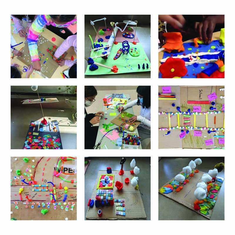
KIDS REIMAGINE SCHOOL STREETS
SPECTACLE Bureau for Architecture and Urbanism, Sustainable Calgary, Everactive Schools, Toole Design, University of Calgary Faculty of Engineering
LOCATION Calgary, Alberta
CATEGORY Community Initiatives
What would streets look like if we built them for kids? This question guided Kids Reimagine School Streets, a collaboration between non-profit organizations, four elementary grade schools in three communities, university students, designers, fabricators, and local community members. The aim: to co-create safe, comfortable, and interesting routes to school; and to empower kids—and the rest of the community—to lower their carbon footprint by walking and biking for daily trips. Active travel reduces pollution and is understood to lead to improved physical and mental health, including better school grades.
This program took kids out of the back seat (figuratively and literally) and got them involved in planning low-carbon, healthy communities. It connected city builders with students’ point of view, and showed kids they can make a difference when it comes to climate change.
Building on the momentum of collaborative co-design workshops, tactical urbanism interventions were implemented adjacent to the three schools, including the Connaught Play Street (2022), Meridian Active Alley (2022), and Martindale Calm Collector (2023). Each intervention encouraged more walking and biking by students and the larger community. Weekly pop-up activities took place at Connaught over the summers of 2022 and 2023, and provided free, family-friendly outdoor events. In addition to the shorter-term interventions, Neighbourhood Active Travel Networks (NATN) proposals were developed that set long-term visions for turning the three school communities into walkable, safe and welcoming places. The aesthetics for the design interventions and networks were inspired by the direction provided by the elementary grade school students, which included bright colours and patterns, and lots of trees and green.
Jury Comment :: When kids, non-profits, schools, teachers, students, parents, designers and fabricators collaborate to create safe and inclusive active spaces, it’s worth celebrating. It gives children a voice and shows them the importance of such spaces. They get exposed to the idea of designing for the future. The project demonstrates effective community collaboration to design safe and kid-friendly school streets, showcasing various examples and strategies implemented in Calgary.
This project stands out for its educational value and emphasizes a fundamental concept in the field: the quality of cities, their developments, and their architecture is dependent on the knowledge, culture, and vision of the people who inhabit them, imagine them, make laws, and ultimately make decisions.
SUSTAINABILITY CONSULTANT/CLIENT Sustainable Calgary | TEAM MEMBERS Vlad Amiot, Jessie Andjelic, Lucia Blanco, Tracey Coutts,Dr. Alexandre de Barros, Tripty Kaur, David Kowel, Roxanne LeBlanc, Celia Lee, Katie Lore, Srimal Ranasinghe, Veronique Ulrich, Philip Vandermey and Vanessa Wang, Grade 4-6 Students at Calgary Islamic OBK, Ecole la Mosaique, Manmeet Singh Bhullar, Connaught School
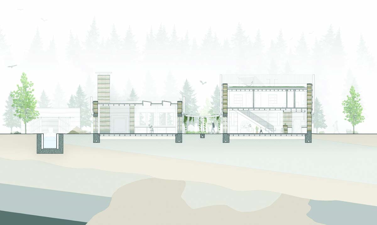
FIELDS AND FLOWS
Preston Stronach, Dalhousie University School of Architecture
ADVISOR Brian Lilley
CATEGORY Student Projects
This thesis project proposes a type of township development that integrates industry with water-based communities toward the promotion of healthy environments and nature-based infrastructural systems. The design site is centered on a kilometre-long section of a sediment-filled shallow river in the community of Fall River, Nova Scotia.
Surrounded by dense woodlands, and nestled between two freshwater lakes, the site is explored through the lenses of industry, inhabitation, and environment. Each is considered in the context of the broader Shubenacadie water system: a waterway that is under immense stress from its various functions, through serving urban centres and agriculture to hosting the world’s highest tides.
To integrate human habitation in an ecologically sensitive manner, new canal locks are proposed to manage water levels and control sediment. Sediment buildup is a major problem in the maintenance of canals and is primarily mitigated through periodic dredging operations. During a three-day, 100-kilometre canoe expedition on the waterway, hand-dredged sediment was collected from the locations of the proposed locks. The sediment was then later catalogued, dried, and recompressed to explore its potential use in the creation of construction components.
Building from this hands-on research, the design proposes a series of rammed earth structures, including a three-storey town centre, a lock-keeper’s house and studio, and an outdoor classroom. Within and around each building, water is recycled and runoff controlled through the use of greywater systems, permeable paving, strategically placed bioswales, and subgrade sand filters.
Through the harmonization of material use, environmental impact, and human habitation, the project proposes an architecture that integrates environmental management with our everyday lives.
Jury Comment :: A thoughtful and historic consideration of an important societal issue—how to protect waterways and promote a circular economy. The project considers how to use the waterway ecosystem infrastructure to benefit the environment while educating visitors about these benefits. The study covers the impact of a large ecosystem, and how it is manipulated and displayed at the point where the public can interact with the system to learn, explore and recreate. It demonstrates an ability to visualize topography on a large scale while remaining sensitive to historical and geographical context.
As appeared in the May 2024 issue of Canadian Architect magazine